Iguazu Falls

Iguazu Falls Tourists Complex
Iguazu Falls and Brazilian tourist complex
Photo by: Martin St-Amant, Creative Commons
Devil's Throat in Iguazu Falls
Devil’s Throat at Iguazu Falls in Argentina
Photo by: Luca Galuzzi, Creative Commons

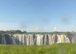
Iguazu Falls, also known as Iguassu or Iguaçu Falls, are situated on the border of Argentina and Brazil. They touch the Parana region in Brazil and the Misione region from Argentina. The falls separate the river into upper and lower Iguassu. The first person to discover the place was a Spanish conquistador named Alvar Nunez Cabeza de Vaca in 1541. It was rediscovered by Boselie during the end of the 19th century.

The Iguaçu have a total of 275 falls and are 2.7 kilometers long. Some of the falls have a height of 269 feet. About half of the river flows into a chasm known as The Devil’s Throat. This particular waterfall is U-shaped, 82 meters high, 150 meters wide, and 700 meters long. Iguazu Falls divide the two countries and more than two thirds of the falls lie in the Argentine Province.

It is said that ten days must be allotted to cover all the falls and do justice to the place. Since the falls are not evenly divided between the countries, enough time must be given to both the countries. The tourists can reach the falls from either the Brazil Province or the Argentine Province. The national park of Brazil and Argentine are now a part of the UNESCO, world heritage site.

Iguazu Falls
View of Iguazu Falls in Brazil
Photo by: Martin St-Amant, Creative Commons

April 8, 2009 at 10:20 pm | 41 comments

Grand Canyon

Grand Canyon
Large beautiful view of the Grand Canyon, USA
Photo by: active metabolite, Creative Commons

The Grand Canyon is the largest known rift in the world. The canyon is a steep-sided gorge that was made by erosion from the Colorado River in northern Arizona. It is because of heavy mineral deposits that the canyon is bright red, brown and orange in color.

This canyon is a part of the large Grand Canyon National Park designated by former president Theodore Roosevelt. The park is almost 277 miles long and varies from 4 to 18 miles wide. The canyons are the main point of attraction in the nation park. Theodore Roosevelt used to come to the national park for relaxation and hunting.

Science shows that the canyons were carved out by the Colorado River some six million years ago with the deepest canyon depth being of over one mile. It is said that the river started cutting layers of rocks from the west initially and gradually moved to the east. The area was inhabited by Native Americans who lived within the caves. The Grand Canyon was considered a holy place for many pilgrims. The first European to explore this part of the world was Garcia Lopez de Cardenas who arrived from Spain in 1540. During the year 1869, Major John Wesley Powell made the first recorded journey down the Green and Colorado rivers through the Grand Canyon.

Some of the best adventures that a tourist can indulge in are river rafting, helicopter tours and other guided tours via land. Visitors can stay in the upscale Grand Canyon hotels and lodges to make the journey even more memorable.

7 Wonders of the Natural World

April 8, 2009 at 9:02 pm | 2 comments

Galapagos Islands

Marine Iguana
Marine iguana at Galapagos Islands in Ecuador
Photo by: strana, Creative Commons

The enchanted Galapagos Islands are said to be one of the most peaceful and unique places on earth. Tourists find it very peaceful and enchanting to explore these wondrous islands. The island chain was formed by many underwater volcanic eruptions over a long period of time. The Galapagos Islands are situated on the equator and have a total population of 40,000 people. The islands are located in South America and the official language spoken there is Spanish. In fact, Galapagos is a Spanish word that means saddle.

The islands are located in the Pacific Ocean and are almost one thousand kilometers away from South America. There are 19 islands surrounded by numerous marine reserves. The location is also known as “the living museum” because of how it showcases evolution. Due to active volcanic eruptions and extreme isolation on the islands, new kinds of animal life evolved. For example, one can see evidence of the evolution of giant tortoises and the land iguana. Both of which are documented in Charles Darwin’s theory of evolution.

Even though the islands are located on the equator, water currents bring cold water to the islands, leading frequent rains all throughout the year. During the period from June to November the average temperature on the islands is 22 degrees Celsius. The temperature rises up to 2 more degrees from December to May with no winds but heavy rainfall. Some of the most visited islands are named Bartholomew, Culpepper, Hood, Narborough and Charles.

7 Wonders of the Underwater World

April 8, 2009 at 8:34 pm | 9 comments

Bali and Its Attractions

Bali's Rice Terraces
Rice Terraces at Bali, Indonesia
Photo by: riza, Creative Commons

Bali is an island in Indonesia that is located at the extreme west of the Lesser Sunda Islands, between Java and Lombok. Indonesia has over seventeen thousand islands with a population of more than 200 million. It also has almost 400 volcanoes, out of which 70 are still active. Though the primary languages are Balinese and Indonesian, English is a common third language and is used for commercial purposes. Most of the local population is either Hindu or Muslim, but there are pockets of Christianity and Buddhism as well. The first people to inhabit Bali were Austronesians in 200 B.C. who had initially migrated from Taiwan. The Bali culture had a lot of influence from Indian and Chinese culture.

Bali is one of the most commercial places in all of Indonesia. It attracts tourists because it is known for its beautiful rice terraces, temples, art, dance, painting, leather and music. Tourists come from all over the world to see its culture, natural beauty, art, and paintings.

Bali has no rail tracks and there are only coastal roads. The entire island is enclosed by coral reefs. The beaches in the south have white sand and the ones on the north and west have black sand.

April 8, 2009 at 8:05 pm | 12 comments

Amazon Rainforest

Amazon Rainforest
View of the Amazon Rainforest
Photo by: markg6, Creative Commons

The Amazon Rainforest, also known as the Amazon Jungle, is located in South America in an area known as the Amazon River basin. While the forest covers several countries, the largest percentage can be found in Brazil and Peru. Smaller portions exist in countries like Venezuela, Colombia, French Guiana, Ecuador, Bolivia, Guyana, and Suriname. The Amazon Rainforest is the largest rainforest in the world and makes up about half of the planet’s rainforest space. It is also home to the greatest river in terms of drainage and discharge.

According to scientists, the Amazon Jungle was created millions of years ago when the Amazon River changed direction from west to east. It most likely formed during the Eocena period following a drop in tropical temperatures.

The Amazon Rainforest is also one of the world’s largest eco-systems, containing one of the most diverse array of species on Earth. Many medical and pharmaceutical agencies run research projects in the jungle, gaining plant knowledge and experimenting with new drugs.

Modern Decline of the Amazon

In modern day, many things are threatening the livelihood of the forest. Foremost among them is the deforestation that is taking place to clear land for farming and raising livestock. Many animals are being pushed out of their homes, as over 100,000 square kilometers were destroyed between 1990 and 2000 alone. Before 1960, access to Amazon interior was restricted, but due to farming practices in the later years, there has been a lot of damage to the Forests. Scientists are not only upset about the potential loss of bio-diversity, but also about the amount of carbon contained within the plants that is being released through destruction of the forest. The amount of gas that could be released could adversely affect global warming.

April 8, 2009 at 7:51 pm | 59 comments

Sistine Chapel

Sistine Chapel
View of the interior of the Sistine Chapel in Vatican City
Photo by: beyond forgetting, Creative Commons

The Sistine Chapel in Vatican City, Italy is one of the most famous chapels in the world. It is also the official home of the Pope. The chapel is the final stop that visitors make when they are taking a tour of the Vatican Museums.

The Chapel has garnered much attention because of its amazing and intricate architecture and artwork that was carved and painted by some of the greatest artists of all time. It has a 12,000 square foot painted ceiling, parts of which were painted by Michelangelo. The paintings depict the life of Christ and Moses and took two to three years to complete. Other artwork by Raphael can be seen within the chapel. Because of these paintings, and the building’s purpose, the Sistine Chapel is considered a very holy and special place.

The chapel in the Vatican City is famous for its many of conclaves, or rooms. The most popular uses of the Sistine Chapel are the masses on Christmas Eve and Easter. During these days Vatican City is crowded with tourists and locals looking to be a part of the ceremonies.

April 8, 2009 at 1:35 pm | 20 comments

Alhambra Palace

Alhambra
View of Alhambra and its reflection on the poor
Photo by: clspeace, Creative Commons

The Alhambra is a palace and fortress located in Granada, Spain. The entire fortress is made up of red clay. The fort is very complex in its architecture. It was built by Moorish who was a ruler in Southern Spain. The Fortress was made on a hilly terrain on the southeast side of the city. Today, the Alhambra is one of the main tourist attractions of Spain. Many years ago it was known to be a residential place of the Muslim rulers. It has some very intrinsic and beautiful Islamic architecture.

The total length of the Alhambra is 740 meters. The strongest walls are at the citadel. Other than the west side of the Alhambra, all the other walls are weak. In total, there are thirteen towers. A river divides the Granada Valley and the Alhambra Park runs parallel to the Monte Mauror.

The Alhambra is a true reflection of the ruler Nasrid Emirate of Granada. A lot of people have used this place as a refuge. This site has a very complex mix of both the natural and manmade features that are worth visiting for. The structure itself reflects the craftsmanship of Muslims.

April 6, 2009 at 5:50 pm | No comment

Louvre Museum

Louvre Museum
View of the Louvre Museum and Louvre Pyramid.
Photo by: McPig, Creative Commons

The Louvre is the national museum of France. It is situated in the capital city of Paris. The museum is considered by many to be the best in the world. The museum covers a total area of 652,300 square feet and has more than 35,000 objects placed in it. Due to its size and vast collection of art and artifacts it is impossible to see the entire museum in a couple of hours. The collection spans from the 6th century BC till the 19th century AD.

This museum was actually built as a living space for Philip II and some remains of its original form are still present. A lot of structural changes have been made to give the Louvre its present look. The museum was inaugurated in 1739. However, due to some infrastructural problems, it was shut down for a period of almost five years. Some of the most famous pieces of art that are displayed include Antonio Canova’s Psyche, the Venus de Milo, the Mona Lisa, as well as Egyptian, Greek, and Roman antiques. The museum has a very rich heritage that has made the French very proud and kept visitors coming through its doors.

Paris Famous Landmarks

April 6, 2009 at 5:20 pm | 25 comments

Canals of Venice

Canals of Venice
View of the Grand Canal from the Rialto in Venice, Italy
Photo by: keepwaddling1, Creative Commons

The beautiful city of Venice is surrounded by water and is located in northern Italy. The capital of Venice is Veneto. It is commonly known as the city of lovers, the city of water or the city of bridges. It is spread over 118 Islands. Venice is very famous in the world because of its numerous canals.

The city has a total of 150 canals and the most important canal in Venice is called the Grand Canal. It is responsible for managing the traffic in water by corridor management. Rather than visiting areas of Venice by car, it is very common to find water buses and water taxis that are used for transportation.

During the day time, the city is very crowded with visitors all across the world trying to experience what the city has to offer. Narrow yet beautiful canals, bridges and streets give a very different feel than many other places.

Motor boats are not allowed to travel in small canals that are narrow. The city has almost 400 bridges and the Grand Canal cuts the city equally into two proportionate halves from the north to the south. The total length of the Grand Canal is three kilometers. One of the constant threats that the city is the weakening infrastructure of the buildings.

April 6, 2009 at 4:58 pm | 5 comments

Palace of Versailles

Versailles Graden & Palace
Garden at Versailles with the palace in the background
Photo by: albany_tim, Creative Commons

The Palace of Versailles is one of the most prominent châteaus in France, located 20 km southwest of Paris. Before the château was constructed, Versailles was only a small village. Today it is one of the wealthiest suburbs in all of Paris. In the late 17th century, Versailles was also considered the strongest political powerhouse where the monarch used to sit. Following the onset of the French Revolution, however, the royal family had to move back to Paris.

The palace covers a total area of 110,000 square meters and includes 700 rooms, 67 staircases, and more that 200 windows. It is home to numerous paintings, handmade sculptures, drawings, objects and furniture from different centuries.

In 1038, the term Versailles was first coined. Construction on Versailles began in 1624 and included more than 36,000 people who worked on it. Its design has also influenced other cities, including Washington D.C., which has a similar layout based on the street grid of Versailles. Its unique design and construction are just a couple reasons the Palace of Versailles is a popular tourist destination.

Paris Famous Landmarks

April 6, 2009 at 4:03 pm | 2 comments

Abu Simbel Archaeological Site

Abu Simbel
Great Sun Temple of Ramses II at Abu Simbel
Photo by: Mrs Logic, Creative Commons

Abu Simbel is the name given to two huge rock temples located in south Egypt about 290 km south west of Aswan. This is an archeological site and it is now registered as a UNESCO World Heritage Site. They are also called the Nubian Monuments. The history of these temples dates back to the 13th century when they were carved out of a mountainside. The entire monument was relocated in 1960 on an artificial hill.

The reason the monuments were shifted is because they were gradually drowning in Lake Nasser. This lake was a huge artificial reservoir that was made by the Nile River and Aswan Dam. The Abu Simbel attracts a lot of tourists every year as it is the most visited spot in Egypt.

Panorama View of Abu SimbelThe temple took almost 20 years to complete. It is a dedication to three different gods, namely the Ra-horakhty, Ptah and Rameses. The Abu Simbel is considered one of the most beautiful and sacred temples in all of Egypt. Every statue in the temple has Ramesses II on a throne and he is donning the double crown of both the Upper and the Lower Egypt. One of the statues at the entrance once got damaged due to earthquake.

The entire temple is marked as a courtyard and enclosed on the north and south side by walls. The Abu Simbel is known for its beauty, mystery and architectural knowledge. Most of the visitors who are on the expedition to explore Egypt come to visit this Temple.

April 3, 2009 at 12:43 am | 6 comments

St. Mark’s Basilica in Venice

St. Mark's Basilica
View of St. Mark’s Basilica with lots of tourists and birds
Photo by: Mohan S, Creative Commons

Saint Mark’s Basilica is a cathedral located on St. Mark’s Square in the city of Venice, Italy. It is one of the attractive cathedrals in the city and it is famous for its uniqueness in terms of the design and the magnificent interior as well as being an example of the Byzantine architecture. Many years ago, however, it did not serve as a cathedral. In fact, it was a chapel for the Venetian City and its rulers. Since the 11th century onwards, the cathedral was known by the nickname “Church of Gold,” or “Chiesad’Oro” in Italian.

The entire cathedral of St. Mark has had both European and Italian artists working on it. That is one of the reasons why it displays the beauty and designs from both cultures. St. Mark’s Basilica is known for its artistic, iconographic as well as religious content and some have described it as being a masterpiece of Gothic sculpture and art. The entire top ceiling is covered with beautiful mosaic colors of gold and bronze, giving it a very bright and lit effect.

The current basilica is the third cathedral that was built on the place because it is where Saint Mark’s body was located. It is divided into three main segments – the lower segment, the upper segment, and the domes. The interior of the cathedral depicts the Greek cross and every arm is divided into three naves.

April 3, 2009 at 12:38 am | No comment

Florence and Its Cityscape

Panorama View of Florence
Panorama View of the city of Florence in Italy
Photo by: Shoes on Wire, Creative Commons

The city of Florence is the capital of Tuscany, a region in central Italy. The city is situated on the river Arno and is known for its interesting history, art and architecture. Over a period of five years, from 1865 to 1870, it was also declared the capital of Italy. The City of Florence has been a part of the World Heritage Site since 1982.

Florence is one of the most attractive tourist destinations in Italy mainly because of its cityscape. One reason why area is so special is that from the 16th century to present day it has lured many artistic masters like Leonardo da Vinci.

Some of the major attractions of the city are the Duomo cathedral, the Florentine skyline and the Loggia dei Lanzi, to name a few. The Palazzo Vecchio Tower bell tower is another icon that has outstanding tourist appeal. The Ponte Vecchio, of the 14th century is another landmark that adorns the city of Florence.

Florence is certainly known for its artistic past. Almost all great Italian artists spent time in this city. The entire area lights up during the evening like a beautiful painting on canvas. Most visitors to Florence come mainly to experience the history, the museums, and the culture normally associated with this centrally located Italian location.

Sunset at Florence
The amazing light glows at Florence during sunset
Photo by: jonrawlinson, Creative Commons
Florence Glows At Sunset
Reverse angle of the glows over Florence at sunset
Photo by: jonrawlinson, Creative Commons
Sunset Over Florence
The Ponte Vecchio at sunset taken from Michelangelo Park
Photo by: stevehdc, Creative Commons
Beautiful Sunset View at Florence
Sunset over Florennce, taken from Michelangelo Park
across the Arno
Photo by: stevehdc, Creative Commons

April 3, 2009 at 12:31 am | 4 comments

Moscow Kremlin

Kremlin
Moskva River & The Kremlin Castle in Moscow, Russia
Photo by: olpol, Creative Commons

The Moscow Kremlin, also called the Kremlin, is a castle that is situated at the heart of Moscow. It has four palaces and four cathedrals and it is the official residence of the president of Russia.

The great Kremlin Palace is one of the biggest castles in all of Russia. It has a very stunning combination of yellow and white with a green rooftop. The golden color adds an appearance of wealth to the entire palace. The palace was initially built in 1462 during the rule of Ivan the Terrible, but was rebuilt in 1837 by King Nicholas I because of the extensive damage that was done to it during wartime. During the 18th century, the construction came to a halt as the entire Russian capital moved to St. Petersburg. It was in the 1740s when an Italian architect was hired by Queen Elizabeth to complete the Kremlin and the construction began once again.

The Kremlin Palace was built to extend the Russian autocracy. The best architects were hired to perform the splendid job and they came up with a fine piece of art. The dimensions of the palace are massive. The total length of the palace is 125 meters and the height is 47 meters. It covers a total of 25,000 square meters. The whole building has nine churches from the 14th through 17th centuries with more than 700 rooms in it. The west side of the palace was for the royal family. Just like many other palaces, this one is also off limits to public viewing.

April 3, 2009 at 12:15 am | 6 comments

Varanasi and Ganges River

Ganges River in Varanasi
Sunrise at Ganges River in Varanasi, India
Photo by: jonrawlinson, Creative Commons

Varanasi, also known locally as Banaras is situated on the banks of the river Ganges in utter Pradesh, India. It is also called as the city of lights and is known to be one of the most sacred places for many Hindus. It is also said that this city is one of the oldest in the entire world.

The river Ganges is known for its outing and the city has also chosen its culture based on the rivers purity and religious belief. Most of the prominent poets, writers and philosophers have been born in this part of the city. It is said that the entire city is blessed by gods, making it all the more popular for the common man of India. In fact, the origin of Ayurveda has also been associated with Varanasi. Followers of the Hindu community call this place the religious capitol of India. One can find thousands and thousands of temples in this city.

According to legend, the city was found some 5000 years ago by lord Shiva and thus is one of seven pilgrim destinations for Hindus. The city of Varanasi is known for its Ghats. It is said that the city owns almost 100 Ghats, some of them being owned privately. Some of the famous ghats of Varanasi are the Dashawamedh Ghat, the Manikarnik Ghat, Harishchandra Ghat and the Mana Mandir Ghat.It is estimated that more the 1,000,000 pilgims visit the city on a yearly basis. It is a belief that bathing the river Ganges will wash away all your sins.

April 2, 2009 at 7:54 pm | 7 comments

Lijiang River and Its Cruise

Lijang River
View of Lijang River (Li River) in China
Photo by: Zingaro, Creative Commons

The Lijiang River is also called the Li River in China. It begins in the Mao’er Mountains and winds its way for many miles through natural scenic beauty and thick bamboo forests with amazingly strange rocky formations. The river then runs south to the county of Pingle where it combines with two other streams.
If you decide to go on a cruise down the river, the entire boat trip takes a total of seven hours. With the help of a good guide, you can learn a lot about the beauty of the river and the history that surrounds it. The journey includes sites such as Pierced Hill, Clean Vase Hill and Embroidery Hill.

Some of the best places to view during a planned holiday tour to the Li River are the Reed-Flute Rock, Seven Stars Park, Mountain of Splendid Hues, Elephant-Trunk Hill and Lingqu Canal. The scenic beauty of Li River in Guilin is used as a common backdrop for a lot of landscape paintings and is the topic of many poems. Common sights on the river include bamboo boats, fishermen and water buffalo. The beauty of the Li River is so mesmerizing that it attracts visitors from all over the world.

April 2, 2009 at 4:08 am | 2 comments

Shwedagon Pagoda in Yangon

Shwedagon Pagoda
View of Lake Yangon with Shwedagon Pagoda in the background
Photo by: antwerpenR, Creative Commons

The Shwedagon Pagoda, also called the Golden Pagoda, is found in Yangon, Myanmar, just west of the Kandawgyi Lake on the Singuttara Hill. The exact height of the Stupa is 321.5 feet and legend states that it was built more than 2,500 years ago, probably during the time of Buddha. But since it was completed, it has been damaged and even destroyed several times by earthquakes and other natural disasters. The initial reason for building the Shwedagon Pagoda was to create a shelter for several strands of Buddha’s hair. Today, the Burmese consider this pagoda to be the most religious one in the region.

One reason why the Shwedagon is so special is because its spire is made up of a thick layer of gold along with thousands of diamonds, rubies, and precious gems embedded in it. The residents of Myanmar contributed gold to the structure to ensure that would be properly maintained. That practice started when the queen of Shin Sawbu donated gold that was equal to her own weight to the building project.

Visitors can access the Shwedagon Pagoda from all four sides of the hill, but they must remove their shoes before stepping inside. On the east and south sides, one can see vendors selling different kinds of items like the flags, books, and images of Buddha. A pair of lions guards the entrance to the Shrine.

April 2, 2009 at 3:56 am | 10 comments

Sahara Desert: Hottest Desert in the World

Sahara Desert
View of Camels at the Sahara Desert
Photo by: bachmont, Creative Commons

The Sahara Desert is the largest and hottest desert in the world. Temperatures can reach as high as 57.7 degrees Celsius, or 135.8 degrees Fahrenheit. It is spread over more than 9,000,000 square km (3,630,000 square miles) as it covers most of North Africa and is as big as the United States. Scientists, however, say this desert expands and shrinks over time. In fact, records show that the Sahara Desert grows southward by about 48 km each year.

The desert starts at the Red Sea, spreads across the Mediterranean, and even over to the Atlantic Ocean. It touches 12 African nations, including Egypt, Chad, Algeria, Eritrea, Libya, Morocco, Niger, Mauritania, Mali, Sudan, Western Sahara, and Tunisia.

Life in the Sahara Desert can be very difficult to sustain due to its climate. It receives less than three inches of rain every year. Rainfall can range from twice in one week to an extreme of no rainfall over the next three years. Oases are scattered throughout this desert. However, the size of the desert makes it difficult to trace where they are located.

Dunes throughout the desert can measure as high as 600 feet. The typical animals found here include domestic camels and goats. As far as the wildlife is concerned, it is common to see scorpions, monitor lizards, sand vipers, wild dogs, ostriches, cheetahs and more. The only types of birds that are visible are African Silver Bills and Black-throated Firefinch.

April 2, 2009 at 2:45 am | 16 comments

Leaning Tower of Pisa

Leaning Tower of Pisa
View of the Leaning Tower of Pisa in Italy
Photo by: McPig, Creative Commons

The Leaning Tower of Pisa is a free standing bell tower of the cathedral of Pisa in Italy. The Tower is located behind the cathedral and is said to be the third oldest structure in Pisa. The tower was made to stand straight, however immediately after it was constructed, it started leaning towards the south east. This was due to a poorly laid foundation and a substrate that allows the foundation to favor one direction.

The total height of the tower is 186.27 feet from the ground towards the lower side and 186.02 feet on the higher side. Its wall width at the bottom is measured at over 13 feet and the walls are 8 feet thick at the top. The tower’s total weight is 14,500 metric tons and has 296 steps on the south side and 294 steps on the north facing side.

The Tower Of Pisa was built over a period spanning from 1173 to 1372 and was constructed in three different phases. It was in 1178 when the Leaning Tower of Pisa had three floors that the tower started to sink. The reason was that only a three meter foundation had been used upon unbalanced soil. Essentially, the design was flawed from the beginning. Construction was halted for almost a century as the city was in a continuous state of war. The soil eventually settled, otherwise, the tower was sure to topple over.

7 Wonders of the Medieval World

April 2, 2009 at 2:20 am | 26 comments

Matterhorn in between Switzerland and Italy

Matterhorn
Matterhorn, lies within the border of Switzerland and Italy

Matterhorn Panorama

The Matterhorn is considered one of the highest mountains in Switzerland with an average height of over 4,000 meters. Matterhorn is a mountain in the west part of the Alps mountain range, called the Pennine Alps. The peak height of the Matterhorn is 14,692 feet and it falls on the border of Switzerland and Italy. The Matterhorn is a German name that means Meadow peak in English.

The Matterhorn has two different adjacent summits with both of them located on a hundred meter long ridge that has rocks covering it. The Matterhorn has a unique pyramid shape due to erosion over the last million years.

A lot of mountaineers love to go hiking up the mountain. The attempted first ascents, however, were not very successful. History shows that scaling the mountain has not been very safe for climbers. The worst incident occurred in 1865 when many people died while climbing the mountain. During a visit to the Matterhorn, one can take a ride on the cable car, a method that is much safer and makes the mountain more accessible.

March 30, 2009 at 10:15 pm | 11 comments

Angel Falls, The Highest Waterfall in the World

Angel Falls
Angel Falls, a waterfall located in Venezuela
Photo by: Inti, Creative Commons

Angel Falls of Venezuela is the highest waterfall in the world. Its total height is 3,212 feet (979 m) and drops from height of 2,647 feet (807 m). The waterfall is located in the Canaima National Park of the Bolivar State. Since the water falls from such a great height, the water is vaporizes with the blow of the winds even before it touches the ground and generates mist.

The Angel’s water falls into the Churun River which is a tributary of the Carrao River. The Angel Falls, falls from the maximum height into the deepest place. On the west part of the Canaima National Park is the Auyantepuy, which is one of the biggest and largest flat mountains ending with the steep slope and has vertical walls. This is where the tepuy falls from. The total height of this mountain is close to 3000 feet. One can view the waterfall from 2 different places. The first option is to see it from the top, sitting in a small airplane and the other one is to see from the bottom, sitting in a boat approximately 3 hours of upstream navigation in the Carrao River and the Churun River. One would have to walk through the jungle that takes you to the bottom, or should we say, the base of the fall.

The waterfall were given a new name when an American aviator found it in the year 1037. It is said that if you ever get an opportunity in your life to visit the Angel Falls, do not ever miss it.

March 30, 2009 at 6:08 pm | 13 comments

Brazilian Carnival in Rio

Dancer From Brazil Carnival
Isabel, a dancer from the Brazilian Carnival in Rio, Brazil
Photo by: sfmission.com, Creative Commons

The Brazilian Carnival in Rio, Brazil is an annual festival that takes place four days before Ash Wednesday, which is described as the beginning of the 40 days fast, called Lent. During the days of fasting, some Roman Catholics and Christians do not consume meat. The reason of the carnival is to bid farewell to some pleasures of the flesh and it is dedicated to Christ’s death.

The carnival in Brazil is a little different from its counterparts in Europe because it has a mixture of the European and African fundamentals, including the music, rhythm, and costumes which change a bit from one region of Brazil to the other. A fine example to quote the differences is seen in the southeast part of the cities where the parade of the carnival is usually led by the Samba schools. Only Samba school affiliates participate in it whereas in smaller towns, there is no public to view the carnival. In those places, the carnival is organized in clubs. In the northeastern section of Brazil, even the common public is allowed to dance and take part in the parade and enjoy it to the fullest as they are made to feel a part of the big show. The Brazilian Carnival in Rio is all about having fun, dancing to the catchy rhythms, and wearing colorful clothes.

The modern carnival originated in the year 1641 as mimicry of the European style of having fun. However, over the years, it has changed and taken from different cultures like Europe, North America, and Africa.

March 30, 2009 at 5:46 pm | 6 comments

Topkapi Palace in Istanbul

Topkapi Palace
Topkapi Palace seen from the sea

The Topkapi Palace is located in Istanbul, Turkey. The construction of the palace began in 1459 by Sultan Mehmed II and at its peak, it housed more than 4,000 people. From 1465 to 1853, it was the official residence of the Ottoman Sultans. In 1924, it was converted into a museum and was under the direct supervision of the Ministry of Culture and Tourism. In 1985, the palace became a part of the UNESCO World Heritage Site.

This palace has four different courtyards along with several other small buildings. Over the years, it has seen many changes, expansions, and destruction due to natural calamities like earthquakes and fires. By the 17th century, the palace was being ignored by the sultanates because they were spending more time in the newer palaces. The Topkapi Palace was only serving as a mosque, a library, an imperial treasury and other minor functions throughout that time period and beyond.
In 1924, the Turkish government decreed that the Topkapi Palace be turned into a museum. Today, the palace is a major tourist attraction which houses several collections, including Islamic manuscripts, weapons, robes, murals and even miniatures. It is operated by the Ministry of Culture and Tourism and only a small section of the palace is open to the public.

March 30, 2009 at 5:25 pm | No comment

Mont Saint-Michel

Mont Saint-Michel
View of Mount Saint-Michel at night in Normandy, France
Photo by: Benh LIEU SONG, Creative Commons

Located in Normandy, France, Mont Saint-Michel (also known as Lee Mont St-Michel) is a rocky island that is famous for being the home for the medieval Benedictine Abbey and church. It was used primarily during the 6th and the 7th century as a stronghold of the Romano and British culture.

One of the stories of legend about Mont Saint-Michel is that the archangel Michael once came to St. Aubert, the bishop of Avranches, and asked him to make a church on this rocky island. However, Aubert kept ignoring him until Michael burned a hole in his skull by using only his finger. In October 709, the oratory, or place of worship, was finally constructed and dedicated to St. Michel. It is believed that St. Aubert is buried there.

In the 11th century, an Italian architect designed the Roman church building of the Benedictine Abbey that was constructed on the mount. There are numerous underground crypts and chapels which help balance the weight of the building and keep the structure supported on the ground.

In 2006, France announced that it would begin building a hydraulic dam that would remove silt surrounding the Mont Saint-Michel to make it into an island once again. The project began in 2009 and was completed by 2013. Tours of the Mont Saint-Michel are available and they typically average between 35 and 45 minutes in length.

March 30, 2009 at 5:08 pm | No comment

Baalbek & Its Ruined Temples

Baalbek
Baalbek, city gate in Lebanon
Photo by: Jerzy Strzelecki, Creative Commons

Baalbek is a small town situated in the Bakaa Valley, Lebanon. The city has made a name of its own because of the monumental ruined temples during the Roman period. During that time, Baalbek was called the Heliopolis, which was one the biggest sanctuaries. This is said to be one of the greatest wonders of the ancient world and one of the best built of the Roman dynasty. These are still preserved as the best piece of art by the Romans.

Some of the gods that are worshipped here are the Harmony of Jupiter, Mercury, Venus and others. The city serves as the venue for the festival called Baalbek International that happens once a year. Almost 85 km from the northeast is the city of Beirut. The Baalbek temple is said to be one of the holiest and peaceful places and it is the biggest stone construction in the entire world.

The origin of the Baalbek is still unknown and different scholars have different thoughts about its origin. Baal means “lord” and this label was given to deity of the sky. It means the Bekaa Valley’s god. Baalbek is also the place of birth of Baal. Most of the tourists in the Lebanon city come here to visit the Baalbek. It is also said that the admiration of Baal is the amalgamation form of the god Jupiter, who was then called the Heliopolitian. It is said that the history of Baalbek is rooted to 5000 years ago. A lot of tourists visit this place because of the spirituality that is attached to it.

March 30, 2009 at 4:02 pm | 4 comments