Kiev Old City


Kiev Old City
Photo by: ezioman , Creative Commons

Kiev City is Ukraine’s largest city, and also its capital. It is situated along the Dnieper River, particularly at the north central part of this Russian country. Kiev is said to be among the oldest cities in Eastern Europe. It was established by the ancient Slavs back in the 5th century. Throughout its history, Kiev has been conquered and made part of many empires. In 1991, following Ukraine’s declaration of independence, Kiev was also declared its capital.

One of the main tourist attractions of Kiev is the Old City within this city. Kiev Old City is a settlement that goes as far back as the sixth century, and is believed to have existed until the eighth century.

It was only during the 1970s, however, when archaeologists uncovered the ruins of a stone palace underground. It is said that the main structure could have been erected during the time of Prince Igor, who reigned from 913 to 945 or by Princess Olga, who reigned from 945 to 969. According to historians, it was Vladimir Sviastislavich, who served from 980 to 1015, who expanded the main palace with fortresses and fortifications covering ten hectares. At one point, the town was renamed Vladimir in honor of Sviatoslavich, but it was later renamed Old Kiev or Upper Kiev. Today, a museum stands in Vladimirskaya Street, near two more archaeological finds: the ruins of two palaces to the south and west of the Church of the Tithes.

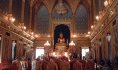
Another Kiev Old City attraction is the Monastery of St. Sophia, built in 957 AD during the reign of Princess Olga. This structure was replaced later by Yaroslav the White, who reigned from 1019 to 1054, who built the Metropolitan Church of St. Sophia right at the heart of the city. Today, the St. Sophia Cathedral remains to be the Old City’s major tourist attraction. Visitors are drawn to the grand mosaics and frescoes that adorn its interiors.

January 22, 2010 at 3:43 pm | No comment

Martha Brae River Rafting


Martha Brae River Rafting
Photo by: blueheronco, Creative Commons

Rafting on Jamaican rivers is another adventure you should add in your long list of things you should do and places to visit. It is definitely a unique and exotic getaway to soothe and relax your ever stressed nerves. The new experience will add life to the usual monotony of sight seeing you do whenever you visit and tour different places.

If you would like to try a new river adventure in Jamaica, you should go for Martha Brae rafting. Rafting in the Martha Brae is unique because the locals use thirty feet bamboo rafts with seats also made of bamboos to tour visitors in a three mile ride. You will surely enjoy the river adventure because of the native feel of the bamboo raft and the views of the river banks.

The river is just one of the many options you have when you go to Jamaica. But when you have already stayed in resorts or hotels in Ocho Rios or Montego Bay, a Martha Brae river visit is simply hard to miss. Many tourists are intrigued by the tales and legends surrounding Martha Brae. According to the legends and what the locals know, there was once a witch who was captured by the Spanish conquistadores because she apparently knew the place where the treasures and gold were hidden. The witch led the Spanish soldiers to a cave where she left them and used her powers so that the river engulfed them and eventually killed them. After this, the witch changed the course of the river so that no person will eventually be killed by their greed for the treasure.

If you are interested to experience the Martha Brae rafting adventure, it is highly recommended that you take the river tour with a special someone. The tranquility and romantic mood of the place will make the two of you even closer. Try the adventure when you visit Jamaica and you surely would not regret the experience.

January 22, 2010 at 3:10 pm | No comment

Taxco

Taxco 400
Taxco
Photo by: FrenchHope, Creative Commons

Because of Aztec and Mayan influence there is obvious evidence of their impact in Mexico through its ancient ruins, temples, and monuments. There is a town steeped in the tradition that makes it comparable to a California gold rush town. That small town is Taxco de Alarcón, also referred to simply as Taxco. Taxco is found in the Mexican state of Guerrero. The “de Alarcon” in the town’s official name is in tribute to Juan Ruiz de Alarcon, a writer who is from this town.

This ancient town has a long association with silver, both the mining of the metal and the crafting of the metal into jewelry and silverware. The town’s reputation with silver, as well as the city’s picture perfect homes and landscapes have now made tourism the premier industry in this area. This comes as a welcome development as the remaining large-scale mining operation in the area is already decreasing its operations and will eventually be closing soon.

What is there to see in Taxco? There’s the Parish of Santa Prisca y San Sebastían, more popular as the Santa Prisca Church. The church stands out because the architecture is of the Baroque style, something not really popular in the small town. The church is made out of very beautiful pink stone is guarded by two towers that have elaborately-designed bell towers.

You may also visit the main plaza of the town, commonly known as the Zocalo, although its official name is “Plaza Borda.” There is also the Borda House or Casa Borda, a building that stands as the most important non-religious structure. It houses Casa de Cultural or the Cultural Center, where you can have a quick lesson in fine arts, sports, and languages. The surroundings of the plaza are a shopper’s delight with silver shops, bars, and restaurants. For an enriching cultural experience, don’t forget to visit the Museum of Viceregal Art and the William Spratling Museum.

January 22, 2010 at 2:35 pm | 1 comment

Wat Pho

Reclining Buddha 400
Reclining Buddha
Photo by: bfick, Creative Commons

The Wat Pho or the Temple of the Reclining Buddha is located in the district of Phra Nakhon in Bangkok. It is also called the Wat Phra Chetuphon. It is near the Grand Palace of Thailand. The temple has made a great contribution by introducing the traditional and famous Thai massage.

Before the temple was made, the place was basically an area where the traditional medicine of Thailand was practiced and studied. This is evident in the many statues on the area that depict varying positions in yoga.

The Temple of the Reclining Buddha is of the oldest and biggest temples in the Bangkok area. It is eighty thousand square meters that house approximately a thousand of images of Buddha as well as the ever famous Phra Buddhasaiyas or the reclining Buddha. It is forty six meters wide and fifteen meters tall. The Buddha has gold plating as its decorations and eyes made of mother of pearl (the soles of the feet has mother if pearl as well). This statue represents the passing of Buddha to Nirvana.

The whole temple or Wat Pho has 2 compounds. The north wall houses the Buddha and the place where massage is studied. The south part contains the Tukgawee which is the monastery of Buddhist monks and serves as the school as well.

The temple is known for being the first university of Thailand were Thai massage has been born. Many famous personalities frequent the place for a relaxing massage. On the walls of temple, text depicting the knowledge behind Thai massage has been inscribed.

You can get a Thai massage which costs reasonably when you visit the place. A more expensive herbal type of massage is also available. If you are interested, the place also offers lessons and courses on the art of traditional massage. You can go to the back of the temple to get these massages.

Bangkok Famous Landmarks

January 22, 2010 at 1:17 pm | No comment

Phuket Island

Phuket Island 400
Phuket Island
Photo by: Shazron, Creative Commons

Phuket is Thailand’s biggest island which is located in the Andaman Sea, south of the country. Famous because of its world class beaches and modern facilities which are at par as the most popular beaches of the world, Phuket has been the ideal paradise getaway for people who would like to relax and unwind.

Despite the devastating tsunami in 2004, the island has fully recovered and is back to catering to more visitors than ever before. Tsunami detection buoys have been put up to serve as warning devices and to reassure the general populace as well as visitors of their safety.

The island is world famous for its hospitable people and the friendly environment. It is perfect for releasing stress and enjoying the natural beauty of nature. With the diverse selections of places to visit which range from beaches to natural rainforests, you are assured of a visit to an island paradise.

Here are some of the many fascinating places to visit in Phuket:
Hat Patong. It is an area which is known for the beautiful beaches where you and companions can enjoy different leisure activities, sport, as well as shopping and recreational activities. The area is a 3 kilometer stretch of crescent bay. The area is complete with amenities for wind surfing, diving or you can choose to lounge around and enjoy the fine weather by sun bathing. Hat Patong also has a very vibrant night scene wherein you can find world class restaurants that offer famous Thai cuisine.

Hat Karon. This is the second largest among Phuket’s beaches famous for the white sand and coral reefs.

View Point. An elevated area where you can enjoy sight seeing and a great view of the surrounding islands

The Wildlife Conservation Development and Extension Center in Khao Phra Thaeo. This is a reserved park where the virgin forests and wildlife animals including endangered species are protected. This institution also hosts a center for research where studies on wildlife conservation are conducted.

Wat Chalong Area. This is the place where the local hero Luang Pho Cham’s statue stands.

So what are you waiting for? Get on board and discover the treasures of Phuket Island!

January 22, 2010 at 1:08 pm | No comment

Notre Dame Cathedral

Notre Dame Cathedral

The 800-year-old cathedral is located on an isle, the Ile de la Cite. Notre Dame Cathedral was built by Maurice de Sully, bishop of Paris. Construction commenced in 1163, during the reign of King Louis VII, and was completed around 1345, a time when Paris had come into its own as a hub for commerce & center of politics. Constructed in an era when illiteracy was the norm rather than the exception, the cathedral features Biblical stories in its portals, paintings, and stained glass design. The cathedral is characterized by ornately crafted spires and other notable features of early Gothic architecture.

Among the momentous moments that have taken place at the cathedral was the crowning of Henry VI as king of France in 1431, and also of Napoleon (as emperor) in 1804, not to mention weddings of historical figures. Crusaders knelt to pray at the cathedral before setting off on their journey and engaging in holy wars. Revolutionaries ransacked and defaced the magnificent place of worship. Notre Dame Cathedral has been pillaged, restored, and has undergone numerous facelifts.

Today, it is both the art and architecture of the Notre Dame Cathedral that mesmerize visitors. The west front has 28 statues that represent Judaea’s and Israel’s monarchs. One will find the famed bell called Emmanuel at the south tower. The legendary guardians – gargoyles that were a fitting addition to the Gothic cathedral as part of restorative work during the 19th century – are on the Grand Gallery. Rose windows of stained glass, a hallmark of Gothic architecture, may not be as extraordinary as other cathedrals in France, but they nonetheless make a spectacular sight. Many historical artifacts, like a 17th century organ, may be seen inside the Notre Dame Cathedral.

Paris Famous Landmarks

January 22, 2010 at 1:01 pm | 1 comment

Arusha National Park


Arusha National Park
Photo by: doug88888 , Creative Commons

Arusha National Park is the cover of a volcano known as Mount Meru in the region of Arusha in north eastern Tanzania. It may consist of a variety of landscapes, but the park is relatively small only covering 52.9 square miles. The Mountain Meru is the second highest peak next to Kilimanjaro.

The park got its name from the group of people called “Warusha,” who live within the area. It is a gorgeous epitome of magnificence that is very wealthy in different species of animals and exquisitely lovely natural resources. Everywhere in the park gives you an opportunity to observe and appreciate the wonders of this world’s natural wild side.

Because of the variety of plant habitats, there are many different genres of animals and over 400 species of birds that live there. Interestingly enough, there are no lions in the zone. There are different types of bucks living near the water including bushbucks, reedbucks and waterbucks. Apart from that, there are also hyenas, warthogs, elephants, monkeys, buffalos, zebras and hyenas.

Some of the most popular attractions at this park include the Ngurdoto and Meru Craters, lakes of Momela and Mount Meru. The Momela lakes are famous bird-watching spots for tourists. You can also go canoeing there while enjoying the scenery. Mount Meru is a volcano climbed by thrill seekers and adventurer seeking people. Those who dare climb the mountain’s summit will be blessed with the wonderful sights that can be seen.

It is highly advisable to visit during the summer season from the months March to July if you are planning to be outdoors. If you’re just there to go sightseeing, Mt. Kilimanjaro is at its best between December thru February.

January 22, 2010 at 11:27 am | No comment

South Luangwa National Park


South Luangwa National Park
Photo by: imolcho , Creative Commons

South Luangwa National Park has been dubbed by experts as one of the world’s greatest wildlife sanctuaries, and not without reason. The ox bow lagoons of the Park and the intensity of game around the Luangwa River are among the strongest in Africa. Aside from being Africa’s most integral major river system, the Luangwa River is also the lifeblood of the Park’s 9,050 square kilometer area.

The Park is home to a wide diversity of vegetation and wildlife. The very famous “walking safari” actually stemmed from this national park and is still one of today’s best ways of experiencing this immaculate wild from the horse’s mouth. The splendor of the Park is enhanced even more by the changing seasons varying from dry, bare mountains in the winter to lush green grasslands during the summer. There are more than 400 species of birds and 60 different animal species. Sadly, the rhinoceroses that used to roam this wonderland have been poached to extinction.

For sure, you would not miss the hippopotamus. As you make your way across the bridge into the Park, you would normally find 30-70 hippopotamuses lolling in the river below and most of the Park’s lagoons will also reveal several. In fact, it has been assessed that for every kilometer of the Luangwa River, there are at least 50 hippos lounging.

Among the primates, the Park is teeming with vervet monkeys and baboons. The Maloney’s monkey is scarcer. The nocturnal bushbaby and the night ape are present but you are unlikely to spot them except during night drives.

Relatively common throughout the Luangwa Valley are hyenas. On most nights, their eerie and melancholic cries can be heard.

If you are staying in one of the Park’s inns, the available guides will make sure that you have every chance of seeing all that the Park has to offer. If you are touring in a car, be certain to first get a copy of the map of the Park from the Crocodile Farm near the entrance of the Park.

January 22, 2010 at 6:45 am | No comment

Vanuatu


Vanuatu
Photo by: flissphil, Creative Commons

Vanuatu is an archipelago situated in the South Pacific Ocean. The island-nation was formed from a volcano. Its early settlers were the Melanesians. It was later discovered by the Europeans, who began settling in the islands by the 18th century. Throughout the 1800s, parts of the archipelago were claimed by France and England, but its citizens eventually claimed and declared independence in 1980.

Vanuatu may be a newly formed republic, but its charm has long made the rounds in the Western and European countries. There are a host of activities to do in Vanuatu, from exploring the seas to bonding with nature and playing extreme sports. But the most fascinating adventure that you can have at Vanuatu is immersing yourself in local culture through a trip to the far-flung island villages. This way, you can have a taste of Vanuatu’s culture and people first-hand.

Should you decide to take this “road less travelled,” you can find accommodations in any of the village bungalows built by the local themselves. They are nothing like your typical hotel, inn or pension house. You should be ready to forego some of the comforts of your home, but be prepared for the thrill of a memorable adventure. Or, you can also try camping out in a tent to see how it’s like to live in the outdoors.

You can also time your arrival in Vanuatu with any of its colorful and unique cultural festivals. The Pentecost Land Dive, for example, which happens on all Saturdays of April to June, is a nationwide celebration of yam harvest time as well as an age-old male fertility rite. The inspiration behind bungee jumping, the rite has local makes constructing a tower from which they would jump off, after tying their feet with vines. There are a lot of events going on the whole year round. Check the Internet for information on the dates to help you plan your trip better.

January 22, 2010 at 6:43 am | No comment

Walt Disney World Resort

Disneyworld castle 400
The Castle at the Magic Kingdom in Orlando, Florida
Photo by: AshuGarg, Creative Commons

Not many people will miss the chance to go to Walt Disney World whenever they are in Orlando, Florida. One of the most famous visitor destinations for both children and adults alike, the Walt Disney World is a favorite place by just about anyone. And why not, when there are so many things to do and sights to see when at the resort. Below are some useful tips when planning a vacation to the Walt Disney World Resort for your family.

Book Early. We are talking about staying at the Walt Disney World Resort. Chances are they will always be full because of the many visitors and tour groups who want to be able to stay there and enjoy. Do log-on to their website and research on what vacation packages are available that will suit you and your family. By booking early, you are saved the stress of having to prepare for any last minute changes should anything go wrong.

Theme Parks Galore! Once inside the Walt Disney World Resort, one will surely have a hard time knowing which theme park to go to first. There’s the famous Epcot Center which is twice the size as Magic Kingdom and is divided into Future World and World Showcase. Everything in this theme park just screams advancement in technology, space age and the like. Another favorite theme park by visitors who visit Walt Disney World Resort is Magic Kingdom. Kids will love the classic backgrounds, the Disney characters who are roaming the area, ready to take a photo op with you and the magical rides that will make the adult wish he was a kid once again.

When going to the Walt Disney World Resort, do remember to take an extra set of clothes as you are surely bound to get wet at some of the water theme parks and do take your camera too so that you can capture all the fun moments you will surely have with your family and friends.

January 22, 2010 at 12:07 am | No comment

Carthage


Carthage
Photo by: upyernoz, Creative Commons

Lying in the eastern side of Lake Tunis, Carthage is one of Tunisia’s biggest tourist magnets. If you are looking for a fun-filled trip with substance and meaning, you should try visiting this uniquely amazing city.

In many history books, Carthage is a popular word for places of war. The strategically located piece of land had captured the hearts of ancient Phoenicians, Romans, and Punics. Although normally known as a war-deserted place, Carthage had successfully survived the test of time without spilling any drop of its cultural wealth. Consequently, it is now a busy place for booming tourism.

The ancient structures built by Carthage’s predecessors still exist nowadays to prove the ancient glory of this ruined city. Although many of these architectural collections had faded and eroded, you can still witness the very structure itself: standing proudly to tell its history.

Other good sites in Carthage would include the following:

• Great Baths – used by the former dwellers as a public pool or as a place for worship
• Parc Archéologique – a place designated for the various Romanian and Phoenician remains, like cisterns, cannonballs, and secret hideouts. It also houses some Punic graves dating as far as the 5th century BC, underground chapels and basilicas from the Roman Catholicism and mosaic pictures depicting certain rituals and ceremonies conducted by the ancients.
• Parc des Villas Romaines – a collection of Roman villas used mainly by the powerful and the rich only.
• Odeon – constructed in 207 AD, Odeon is a vast hall located in hilltop. Many researchers believed that Odeon is a site of town festivities or annual celebrations. Now, the only remains that you might see is its platform.

Truly, visiting Carthage would be an instant time travel. There, you could actually see the places mentioned in many general reference books and you could also feel the presence of years of exploitation. This refreshing change of scenery is indeed an effective icebreaker for your stressful urban life. Why not visit Carthage in your next vacation and witness the merge of cultural milestones?

January 21, 2010 at 10:38 pm | No comment

Ofu and Olosega


Beachfront of Haven
Photo by: sarah rose, Creative Commons

Calling all beach buffs and nature aficionados! This place is for you. Ofu and Olosega (American Samoa) are the historical vestiges of a volcanic doublet with a constricted passage of coral reefs separating each other. The best part is that it is just an overview of the landscape because the Samoan Islands has a lot in store for you.

With a relatively small population, this haven is the perfect getaway for waterfront fanatics who love the rural setting. Living in small huts with a combination of white sand and the site of jagged mountains and serene waters of the Island, this is truly a tropical paradise for relaxation and getting away from the urban life.

Ofu is the western part of the island while Olosega is situated in the northwest area of the island. Ofu is best known for the small village and the 494m Tumutumu Mountain. During your exploration, by late afternoon flying foxes (bats) are prevalent which makes the journey more enticing. This beautiful paradise now belongs to the National Park of American Samoa. The Mountain of Olosega Island is the Piumafua Mountain which stands 639m tall. Traveling the mountain is best for bird-watchers as the location of the hill acts as an aviary to almost 82 species of birds.

Staying in this Samoan Island is not a very hard job. Learn to familiarize yourself with their customs, asking permission before taking photographs is a must, avoiding eating or drinking while walking is also a part of their tradition. If you and your relatives plan to snorkel, covering self with shirts and shorts on top of your swimsuits is essential to give respect to mores. Casual attire is shorts and below the knee get-ups.

So what are you waiting for? Get up from your seats and enjoy this paradise.

January 21, 2010 at 10:35 pm | No comment

The Ruins of Merv


The Ruins of Merv
Photo by: joshua_kucera , Creative Commons

The birth of Central Asia is considered one of the most important events in history. Coming here will allow you to appreciate the hidden treasures in this former Union Soviet territory.

One of those treasures is the Ruins of Merv found in Turkmenistan. Although the place is generally unknown to foreigners like you, the place is indeed a good rerun of what the ancient Silk Road looked like. Here in Merv, you can witness these five structures: Erk – Kala, Bairamalikhan – Kala, Gyaur Kala, Abdullahkan – Kala and Sultan – Kala. These monumental architectural wonders are still standing from the ground, despite the many calamitous events it had experienced. Now, most of these previously stunning monuments are greatly affected by erosion, weathering of the rocks, and age. Still, the very foundation and frame of the five structures are completely preserved, enabling visitors like you to barely see its original form. Besides, the form is unimportant. The more essential factor here is finding the message from the ruins, and discovering the important roles that our ancestors had contributed to us.

Other features include the ruins of numerous mosques suspected to have been used by ancient Arab dwellers for their worship activities, a 40–meter high mausoleum of Sultan Sandzhar Dar-al-Akhir with its stellar dome made from thin bricks, ruins of many other fortresses used by famous ancient sultans, and many more. The attractions are really endless and the culture importance of each is indeed meaningful enough to be mentioned in history books. To further prove that, the Ruins of Merv is now included in the World Legacy list of UNESCO.

In case you would want to explore the rich past of Asian cultures, mainly on the Arabian and Muslim focus, be sure to consider Turkmenistan as one of your preferred options. Having the chance to revisit the centuries of cultural change is a chance you should grab at once, and you can do this in the Ruins of Merv.

January 21, 2010 at 9:59 pm | 1 comment

The Rwenzori Mountains


The Rwenzori Mountains
Photo by: sarah_mccans , Creative Commons

The Rwenzori Mountains is a mountain range stretching up to 120 kilometers. A gem of Uganda’s tourism industry, this snow-capped chain of mountains is otherwise known as the Mountains of the Moon, as it was first described by geographer, astronomer and mathematician Ptolemy. This range reaches a maximum elevation of 5,109 meters at its peak, making it the tallest mountain range in the whole of Africa. In terms of elevation, the Rwenzori Mountains is next only to Mount Kenya and Mount Kilimanjaro, both of which are free-standing mountains.

The majesty of this mountain range makes the National Park a favorite adventure spot of traveling mountaineers. The snow-capped peaks can be seen from miles across the base, but regular hikers are only allowed up to the 1,600-meter slope zone. Beyond this lie areas that only serious hikers may explore. A World Heritage Site as declared by the UNESCO, this mountain range promises a memorable experience to hikers who will dare to conquer its seven days-six night loop—a trail passing through its central circuit and all the way through the vegetation zones. Shorter hikes are also available for those who are not up to challenging the central circuit trail. The features of the mountain range change over time, and so every visit is always different from the previous.

This mountain range is also home to a diverse ecosystem, from large mammals to various trees and plants. The trail itself is a postcard scene: monkeys in trees that welcome hikers to the moorland zone, a carpet of lobelias, pure snow and dark tall rocks.

All in all, this 998-square-kilometer natural wonder nestled in the border of Congo is a sight to behold and an experience to remember.

January 21, 2010 at 9:07 pm | 1 comment

Trunk Bay


Trunk Bay
Photo by: imagesbyferg, Creative Commons

The US Virgin Islands lies two hours from Miami, making it a place to experience the Caribbean without having to take a long flight and spending a lot of money. The US Virgin Islands are composed of three islands—St. Crois, St. Tjomas, and St. John. Each island has a distinct character. For example, St. Croix is a quiet, laidback place, while St. Thomas is full of activity. St. John, on the other hand, promises a memorable eco-trip experience.

Trunk Bay, located on the shores of St. John and part of the National Park, is just one of the US Virgin Islands’ world-class beaches. In fact, Trunk Bay is considered among the most-photographed shorelines n the world. It has a strip of sand that juts out of the coast, giving it a heart-shaped edge. It is named after the Leatherback turtle, which is locally referred to as Trunkschildpatt. To get to Trunk Bay, you will have to pay an entrance fee. But the experience that lies ahead is priceless, as they usually say.

What to do in Trunk Bay? The sea features a snorkel trail that even kids can explore. Aside from the schools of colorful fish that are waiting to be discovered underneath, the trail also gives snorkeling an educational twist. You will find signs underneath, giving you information about the fish. After snorkeling, you can relax underneath the rustling leaves of the palm trees while eating a delicious snack.

Concerned about safety? There is no reason to be, because lifeguards man the bay 24/7. A snorkel rental shop, a gift shop, phone lines and picnic huts are also set up for visitors’ convenience.

January 21, 2010 at 9:02 pm | 2 comments

Upolu


Upolu in Taiwan
Photo by: Jorge P. Price , Creative Commons

Across the Apolima Strait and twenty kilometers southeast of Savaii lay the island of Upolu. Among the islands of Samoa, Upolu is the second largest with a land area of roughly 1,115 square kilometers. Apia, the capital city of Samoa, is also located in this island which happens to be the most densely populated with a total population of 115,000.

The inlands of Upolu are rugged, tropical, and lush green. Its highest point is Mt. Fito that reaches 1,158 meters high. Year round, the season is relatively warm, with 29 degrees Celsius as its average maximum temperature. Between the months of November and March, rains may fall but from May to November, the season gets cooler again thanks to the trade winds from the south east.

The coast of Upolu is lined with many beautiful beaches, tumbling waterfalls, clear flowing rivers, traditional villages, and superb fringing reefs. Found in its interior are mountains and rainforests. The harbor of the northern coast of Upolu provides the main port of the country.

Visitors have the ability to take in the sights of Upolu because of the excellent network of roads there. Among the highlights of the island are the majestic mansion of Vailima that was once the home of the renowned author, Robert Louis Stevenson, and the Paola Deep National Marine Reserve that is lined by walls of colorful fish and corals. Also, Upolu offers Lake Lanotoo National Park and Le Pupu-Lue National Park that cater to nature lovers.

The other major attractions in the island include Lalomanu Crater Walk, Aleipata Coast, Sapoaga Falls, Fuipisia Waterfall, Piula Cave Pool, Togitogiga Falls, Sanupu and Satoa Conservation Areas, Peapea Cave, Papapapaitai Falls, and the south coast beaches. The most common activities done here by visitors are walking, diving, swimming, snorkeling, and surfing.

January 21, 2010 at 8:59 pm | No comment

Kenting National Park


Kenting National Park
Photo by: donut_p , Creative Commons

Kenting National Park is divided into the north and south by the Hegchun valley plain. It was established on the first day of 1984 and is Taiwan’s first national park.

You can find it in Hengchun, Pintung County. It contains a vast number of Taiwan’s population and its size of 333 square kilometer includes 181 square kilometers of land. It consists of a variety of animal species which will bring enthusiasm into the hearts of this world’s animal lovers. The vast number of species includes 310 kinds of birds, 216 types of butterflies, 21 kinds of freshwater fish and various species of mammals, reptiles and amphibians. The place also owns a series of bedazzling landscapes which extend from the north to the south. The movement of the crust is mirrored through its topography and has caused much movement on the peninsula which makes everything very interesting for geologists.

Worldwide, Kenting National Park is actually known as the haven for water lovers because of its beautiful sea. It is really the epitome of a heavenly paradise. Aside from the many kinds of animals, you can also find here various species of endangered plants-including the Taiwanese orchids. Going here will assure you a good chance for recreational activities, and a providence of luxury, relaxation and pleasure. You are sure to enjoy here the enchantments of its natural resources.

January 21, 2010 at 8:47 pm | 2 comments

Hwange National Park


Hwange National Park
Photo by: twonickels, Creative Commons

The land that was once the home of the wandering Bushmen is one of today’s most renowned national parks. Thousands of buffaloes and elephants walk the land. Lions are the common attractions, while it is almost impossible to catch a glimpse of the leopards and rhinoceroses. More than 100 different species have been recorded to live in this sanctuary.

Throughout the park are shallow pans that assist dry season game viewing. Elephants are provided by the natural salt-licks with their favorite mud holes where they can wallow while 60 manmade water holes provide them with their much needed water during winter since everything begins to dry up. There are a number of water holes with raised sides made of wood that allow visitors to observe animals for long hours.

Hwange National Park is also a paradise for bird watchers because over 400 species of birds are found here, specifically during the wet season. The biggest of these species is the Kori Bustard that dwells on the ground. It will only take flight when it is of extreme necessity. The beginning of the mating season is marked by abundant food marks, red bishops model their astounding scarlet plumage, and crowned cranes flounce in a comical dance.

The months from July up to September mark the dry season. During this time, it can be really hot during the day but on winter nights, the temperature can drop very low, sometimes even below the freezing point. The animals, during this season, come together to assemble around the manmade water holes because without these, they would surely die of heat and thirst. During the rainy season though, the vegetation flourishes because big cumulus clouds shower the land with the summer rainfall. During this time is when birdlife is most astonishing.

January 21, 2010 at 8:41 pm | 1 comment

Great Zimbabwe Ruins


Great Zimbabwe Ruins
Photo by: ctsnow , Creative Commons

Thirty kilometers southeast of Masvingo lay the complex of ruins known as Great Zimbabwe Ruins. Zimbabwe is a word derived from ‘dzimbahwe’, a Shona word that means “great stone building”. This is how the modern country Zimbabwe got its name.

The Great Zimbabwe Ruins are located beautifully in a lush and flourishing valley situated at the head of the Mutirikwi River. Studies and investigations done by numerous archaeologists reveal that this valley and the hill that dominates it where most of the ruins are located were inhabited by various tribes from an early period.

The early men dwelled inside the caves found there and by the fourth century, the Gokomore ethnic group, which was evidently the first people of the Iron Age, stumbled upon the place and uncovered the advantage of the land in the Mutirikwi Valley. It was a haven of fecundity in the rough country of Africa, with lovely zephyrs gusting across the valley producing a soft and healthy atmosphere, making it a very suitable place for a king. Because the hill dominated the valley and was easy to defend, it is not surprising that the first Iron Age people became deeply attracted to it.

The hill became overcrowded because it was inhabited by so many people over the years. The people then formed walls by piling up granite rocks and stuffing the insides with rubble. These walls served as platforms that allowed building sites to be obtained. Then, the traditional African huts with walls made of mud were built on the level surface.

Evidence suggests that the king, the soldiers, and the priests of Mwari stayed on the hill while the queen and the majority of the people dwelled in the valley. An impressive and particularly huge stone wall surrounded the king’s residence.

Ironically, the immense wealth of Great Zimbabwe was also its downfall because after it was discovered in the 1870s, adventurers from Europe began arriving in droves. There were even rumors up to now that Zimbabwe is the “land of Ophir” where King Solomon acquired tons of gold.

January 21, 2010 at 8:33 pm | No comment

Sao Jorge Castle

Sao Jorge Castle 400
Castle of Saint George up on a hill above Lisbon
Photo by: Bernt Rostad, Creative Commons

Saint George Castle or Castle of Sao Jorge has a captivating aura, a structure you can practically see from anywhere in the city. It is located in the highest hill of Lisbon and enjoys a clear view of the river. This was once used as a fortress, but these days, it is home to many families and a famous destination for the visitor.

Taken from the Moors, who used it as a royal residence until 1147, Castle of Sao Jorge covers an area about 6000 square meters wide with a number of towers. King Alfonso Henriquez was the one who won this castle with the help of the crusaders. They were on their way then to the Holy Land. When it was conquered, it was dedicated to the patron saint of England, Saint George, commemorating the 1371 Anglo-Portuguese pact. Thus its name became Saint George Castle. It became the royal palace until the 1755 earthquake destroyed it.

Part of the old royal palace and the São João de Deus Hospital weren’t reconstructed at all, or were partially done only towards the end of the 20th century. The Royal Palace people know these days is not the exact reproduction of what it was before. It is more of the result of the most important influences from the various ages that molded it.

Past the main gate of Castle of Sao Jorge is the statue of King Alfonso Henriquez and a string of cannons which remind the visitors of the castle’s original function. The former Alcacovas Palace where the kings of the middle ages lived is now a stone building housing a restaurant. One thing visitors should not miss here is the brilliant multimedia exhibit about Lisbon’s history called Olissiponia. Images are projected on a ten-foot wall with narration, giving people an overview of the story behind the famous city they are in. It also contains the simulation of the great earthquake and the tidal wave in the city harbor.

Next time you plan your travel destination, why not choose to set your feet on the Castle of Sao Jorge and enjoy the view of historical Lisbon.

January 21, 2010 at 5:33 pm | No comment

Torres del Paine National Park


Torres del Paine National Park
Photo by:
Ianlayzelluk
, Creative Commons

What makes a park a good place to visit? Some criterions do not just fall on it being a beautiful one with lots of different animals to see, but the real quality falls on it being an intact and unspoiled place where you’ll not only encounter living things but also get in close contact with the wonders of nature. And, the Torres del Paine National Park in Chile is one of those boasting both wild animals and beautiful forests in one majestic place.

This National Park, located in the South Side of Santiago Chile may be a secluded place, but its spectacular view certainly outshines the inaccessibility and remoteness of the place. Torres del Paine National Park is considered a special park to visit because of the following reasons:

1. The major mountain attractions
– For nature lovers, this National Park will definitely suit your preference. The Paine Massif is said to be one of the most luring and appealing spots to go to coupled with other mountains with the likes of the Paine Grande – the highest mountain in the park, the Cuernos del Paine, and the Torres del Paine consisting of three granite towers that would surely delight every climber in the land.

2. The flora and fauna attractions
– There are many different kinds grasslands and plants to see in Torres del Paine National Park and some of those are calafate – a small plant life bearing berries, and the bonsai.

3. Great hiking, trekking, and rafting adventures
– These activities makes Torres del Paine National Park a lot more enjoyable to visit. While hiking, get upclose views of the animals and plants that live in the National Park.

January 21, 2010 at 2:03 pm | No comment

Moorea


Moorea
Photo by: slm , Creative Commons

Moorea is said to be the ideal honeymoon destination in the planet. This high island from the French Polynesia territory lies a few kilometers shy of northwest Tahiti. You would probably find this place often featured in wedding magazines and other websites meant for traveling couples.

In Tahitian, the name Moorea literally means yellow lizard. There are other names of which this island is referred to such as York Island and Aimeho. One of the most fascinating facts about this island is that the entire area resembles the shape of a heart. However, this is not necessarily the reason for this place to become honeymoon central.

There are many reasons a tourist would find this place very attractive. It offers a great view of the sea and the island is filled with trees. The sea breeze is constant which makes your stay very cool and comfortable even as you walk under the sun. There are a number of different resorts which offer great facilities to cater to your every need. There are many activities being offered such as snorkeling, hiking and other water-related leisure interests. If you seek relaxation at its finest, there are spas which offer various treatments to soothe all the stress away.

Practically speaking, the most enticing feature of Moorea would be the accommodations. There are some cottages which are built just on top of the reef. You can have the full view of the island and the sea from your window. There are also some rooms or cottages which offer great facilities inside. This would also include a glass floor which will enable you to see the marine life and the beautiful coral reef just beneath your floor. There is much to see and a long list of things you can do in this island where you can have the privacy you need while you enjoy every moment of your stay.

January 21, 2010 at 12:26 am | No comment

Castillo de San Pedro de la Roca


Castillo de San Pedro de la Roca
Photo by:
slo poke
, Creative Commons

The Castillo de San Pedro de la Roca is a famous historical fortress built on the coast of Santiago de Cuba. It has been appointed as a UNESCO World Heritage Site in the year 1997, representing one of the best preserved and perfect examples of a Spanish-American military structure. The fortress was built in the 17th century as ordered by Spanish King Philip II for the city’s protection against roaming pirates. Juan Bautista Antonelli, an Italian military engineer, designed the fortress’ unique structure. It was expanded in the 1638 under Governor Pedro de la Roca and further reconstructed in the years that followed.

The unique design of Castillo de San Pedro de la Roca is intended for the steep side of the fortress’ location. When on top, the coast and other small islands can be seen which is very fulfilling for the eyes. Walking inside the fortress provides an appreciation of ancient architecture and an individual can feel what life was like in early times. It was built to protect against pirates, so there are many terraces, defensive walls and bulwarks constructed adding to the fortress’ magnificent design. In the 18th century, some of the fortress parts were used as a prison for political threats. These parts are The Rock or La Roca and The Star or La Estrella. In the early 20th century, The Rock has been damaged but successfully restored by Francisco Prat Puig. Currently, the fortress’ beauty is fully restored and truly rewarding.

Have an appreciation of the ancient infrastructures with a trip at Castillo de San Pedro de la Roca. Bus trips are available for tourists but it can also be reached through a taxi for a little higher price. Arrival of tourists is in highest number during summer and this is the best time of visiting it because the weather is good. Have a trip to this famous fortress and appreciate its rich history.

January 20, 2010 at 11:19 pm | No comment

Redwoods National Forest

Redwood 400
Redwoods National Park
Photo by: Zest-pk, Creative Commons

Visitors have a misconception that a trip to California should solely be dedicated to visiting any place associated with the film industry. What visitors forget is that no trip to California is complete without visiting the northern coast of it. There you will find one of the most massive tree species in the planet. These trees along with indigenous flora and fauna thrive in the Redwood National Park.

131,983 acres of cultural resources and pristine coastline is the best destination for those who want to experience nature in all its glory. The redwood forest grows trees that are documented to be almost 2,000 years old. Just imagine having the bragging right of touching the oldest living organism on earth.

The Redwood National Park’s ecosystem is able to preserve numerous rare animal species. A day trip in the park beats going to the zoo with the probability of coming face to face with over 40 species of mammals and 400 bird species. Add to that the adventure of experiencing their habitat and appreciating the wonder of life all around you.

If you want to stay over night, there are assigned camping sites where you can commune with nature for a longer period of time. An over night family excursion promotes bond that can never be replicated in any other way. If you’re worried about safety, rest assured that there are more than a hundred employees to help you make your stay memorable and safe.

The Redwood National Park is the place to visit if you want to wonder at nature’s abundant blessings. It is an ancient forest that harbours all life forms. It gives communing with nature a whole new meaning as you get to enjoy modern amenities while being isolated from all that defines modern technology. A trip to California is never complete without going down north to this park.

January 20, 2010 at 8:34 pm | 3 comments

The Qasr Amra


The Qasr Amra
Photo by: Paul Mannix , Creative Commons

The Quseir Amra is one of the many Desert Castles in Jordan. The Castle is considered as the best known among the desert castles in the country. The Quseir Amra was built during the early 8th century by the caliph Walid I. Quaseir. Amra’s significance is due to the fact that it depicts the best example of early Islamic architecture and art. The person who discovered the ruins was Alois Musil when he found it in 1898. An Austrian illustrator who sketched the frescoes for a book has even popularized the artwork of the structure to the West.

Only the foundation of the building remains as of today and the larger complex which contains an actual castle is gone. A country cabin which serve as retreat place for the royals still stand in the area. If you pay a visit to the place, you will be able to see the notable frescoes on the ceiling. An interesting and intriguing art work of a naked woman on a bath chamber can be seen as well. Above the area is a piece of art accurately illustrating the zodiac. These are just some of the reasons why the Quesier Amra is considered as a UNESCO world heritage site. This makes the Amra as one of the three recognized by UNESCO in the country.

Aside from the great remnants, its strategic area which is close to the highway and near the city makes it a frequent tourist attraction. Its status as a world heritage site has even generated more and more visits for the place from people all over the world.

Don’t miss the Quiseir Amra if you happen to tour the country or if you are really interested in early art or archaeological treasures of the past. It will surely give you a taste of history as well as a panoramic view of the legendary Sand Castles of Jordan.

January 20, 2010 at 6:47 pm | No comment